HOME |
| |
|
The
Douglas County Recorder of Deeds have records of all
land transactions back to 1886. Earlier land
transactions may be on file if the parties
re-recorded the transaction after the courthouse
fire of April 1886. The following sets of plat maps
exist:
|
|
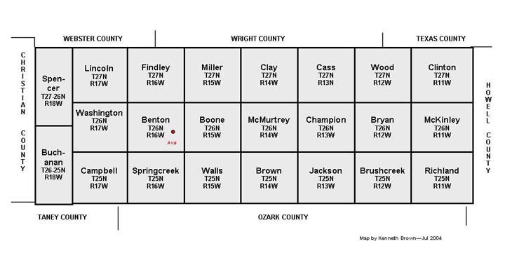
1846-47
Survey Maps -- A few surnames were recorded on this
earliest survey map. A copy is on file in the
Douglas County Museum.
|
-
In
the 1840s, the Federal Land Office in St. Louis,
Missouri, contracted with independent surveyors to
go
through the entire area that included present-day
Douglas County, Missouri. As the surveyors
completed the
field work, they laid out the legal townships,
ranges, and sections that have been used since
that time to
assign land title.
-
No
legal claim to Douglas County land was documented
prior to the completion of these
surveys. (According to Bessie Selleck,
in her 1952 book, "Early Settlers of Douglas
County," Sarah Lawrence
was the first homesteader in Mar. 3, 1847.
Her land parcel was in Twp. 25 - Rng 18.
Using the map below,
one can see that Sarah Lawrence's was in the
extreme southwest corner of the county).
-
As
the surveyor conducted his work, he prepared
maps that showed roads, streams, mills, and the
surnames of any residents he discovered along
the way. Click Here
to see a listing of the surveyor's notations
listed by township, range and section.
|
|
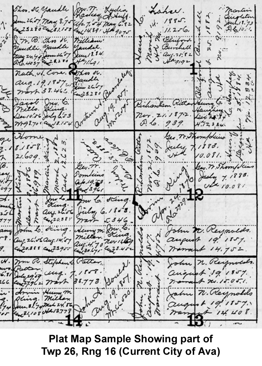
1886 July Plat
Maps. {prepared by the Federal Land
Office in Springfield, these plat maps show the
original land patentee for each parcel as of July
1886. The maps are indexed. A set of the
maps can be acquired from the Douglas County Hist/Gen Soc.
|
-
In 2004,
a set of old plat maps was discovered in a vault
in the Douglas County Courthouse (by yours
truly). Apparently, they were created by the
Land Office in Springfield, MO, after the Douglas
County Courthouse fire of April, 1886, which
destroyed most county records including all land
records. With these plat maps, the county
was able to begin its land records system
again. These 1886 plat maps show the person
to whom the U.S. Government issued each parcel of
land as of July 1886. (The maps DO NOT show
subsequent land holders to whom the original owner
might have sold the land before 1886).
-
Prepared
by hand back in 1886, these maps show the original
land holder's name, the date of the acquisition,
an indication of the type of acquisition and then
a reference number. The plat maps indicate
three ways in which these early settlers acquired
land: (1) by "proving up" a homestead, (2) by land
warrants (issued to veterans), or (3) by cash.
-
Cost:
$15.00 + $3.00 shipping. Send orders to the
Douglas County Historical and Genealogical
Society, Inc. P.O. Box 986, Ava, MO 65608.
|
 |
 |
|
ca
1930 Plat Maps -- These plat maps with indices,
shows the land holders in the 1930 just before modern
roads came to the area. A set of the maps can be
acquired from the Douglas
County Hist/Gen Soc.
|
-
A
few years ago, Nancie Todd Weber prepared a
fully indexed set of plat maps (circa 1930) for
the Douglas County Historical and Genealogical
Society. This publication is a 'must-have'
for any serious researcher of Douglas County
history and/or families. (Click here to
see how to acquire this publication).
-
The
University of Missouri has placed 1930 plat maps
online that appear to be the same ones (without
index) as those of Nancie Todd Weber.
(Click here to see those
online 1930 maps)
-
In
the 1920s, the current state highway system was
not in place. Besides showing all the land
holders in
the 1920s time period, the maps show some of the
old roads that our ancestors used.
|
|
1964-65
-- The Douglas County Landowners 1964-65 Book
is available from the Douglas County Hist. & Gen.
Society. CLICK
HERE to view their publications list,
and order instructions.
|
| |
|
Family
Maps of Douglas County, Missouri, Deluxe Edition
(2006), published by Arphax Publishing Co. --
www.arphax.com
|
-
By Gregory A. Boyd. 344 pages, with 77
total maps. There are 3 maps for each of the
24 Congressional townships that make up
Douglas County. Each Township has a Patent
Map, Patent Index, Road Map, and a Map we
call an Historical Map, which includes
Waterways, Watercourses & Railroads. The
Road and Historical Maps also include the
City-centers and cemeteries that can be
found at NationalAtlas.gov. There is also a
Surname/Patent Index and a Surname/Township
Index to help you dive into the right area
of the County. Included Appendices identify
multi-Patentee buying groups and also list
the numerous Aliquot (section) parts you
might find. This book is constructed to last
with a plastic spiral binding, acid-free
paper, and a tough, laminated cover.
|
|
| |
|